asvi
|
Contents: Description, Arguments, Usage, Examples, Images, Related Functions, Source Supported Under Version: > 1.00
Description Generates an Atmospheric and Soil Vegetation Index map
Arguments and Return Values Arguments: 1- or 2-dimensional greyscale images representing near-infrared, red, and blue spectral bands (all three are required) Return Value: A float greyscale image
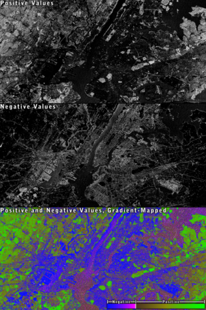
Usage Syntax: asvi(nir, red, blue) This function is part of the larger class of vegetation-index methods used in satellite image-processing. See ndi or this discussion of related functions for more detailed information. ASVI is of the subtype which will return both positive and negative values. Positive values generally indicate the presence of vegetation (with greater values indicating healthier vegetation). Negative values generally indicate a lack of vegetation (water, rock, soil, etc.). The formula used is: ASVI = NIR + 0.5 - (0.5 * (Sqrt(((2 * NIR + 1)^2) - 8 * (NIR - (2 * Red) + Blue))) This formula was obtained from "Above-Ground Biomass Estimation of Successional and Mature Forests Using TM Images in the Amazon Basin" (Dengsheng Lu, Paul Mausel, Eduardo Brondizio, and Emilio Moran, 2002).
Examples dv> nir 2000x1000x1 array of float, bsq format [8,000,000 bytes] dv> r 2000x1000x1 array of float, bsq format [8,000,000 bytes] dv> b 2000x1000x1 array of float, bsq format [8,000,000 bytes] dv> result = asvi(nir, r, b) Generating an Atmospheric and Soil Vegetation Index image. 2000x1000x1 array of float, bsq format [8,000,000 bytes] dv> max(result) 1.101486206 dv> min(result) -0.3954681158
|
DavinciWiki Mini-Nav Bar Contents
Contact Developers
All other topics
Recent Library Changes Created On: 07-16-2012 |

